There are two theories explaining the formation of the Rift Valley.
They are;
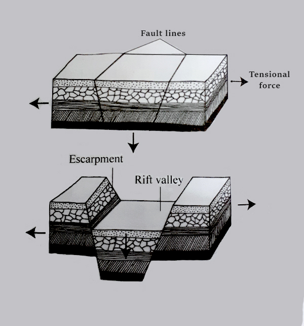
a) Tension theory
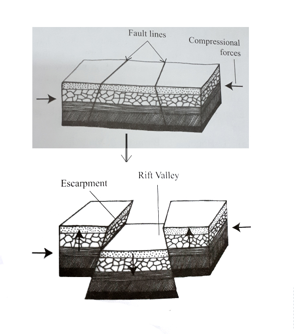
b) Compressional theory
Forces called tensional forces pulled the blocks of land apart causing cracks known as faults to form.
The land between the faults sank to form a huge valley. This valley is called the Rift Valley.
- Compressional forces pushed the blocks of land towards each other causing faults.
- The land between the faults sank to form the Rift Valley. The land on the sides rises to form escarpments.
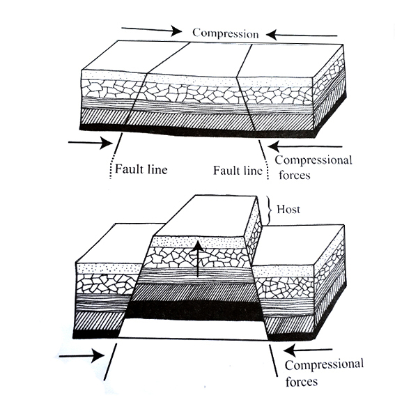
Block mountains are also called horst. When compressional forces pushes hard rocks towards one another, faults form. The land between faults rises to form a mountain.
Examples of block mountains in Africa are;
Pare and Usambara mountains in Tanzania, Ruwenzori mountains found at the border of Uganda and DR Congo, Danakil Alps of Ethiopia, Mau Ranges and the Aberdare Ranges of Kenya.
Ruwenzori Mountain is the highest block mountain in Africa.
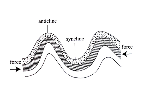
When pressure compresses young sedimentary rocks, they buckle up and form up-folds and down-folds.
The up-folds form fold mountain ranges while the down-folds form depressions or valleys.
The down-folds are called syncline while the up-folds are called the anticline. Examples of fold mountains in Africa are the Atlas Mountains in Morocco, the Cape Ranges and the Drakensberg in South Africa.
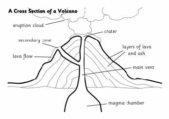
Volcanoes are formed when hot liquid rock or magma and gases are forced through a vent to the earth’s surface.
When liquid magma from a volcano reaches the surface, it is called lava.
The lava cools, hardens and piles up on the surface of the earth forming a volcano.
Examples of volcanic mountains in Eastern Africa are Mt. Kenya, Mt. Longonot, Mt. Kilimanjaro, Mt. Meru and Mt. Elgon.
Other Volcanic mountains in Africa include Mt. Cameroon in Cameroon, Mt. Jebel Marra in Sudan, Mt. Nyiragongo in the DRC and the Tibesti mountains in Chad.
- Residual mountains are found in plateau areas of Africa.
- They are formed when softer rocks are eroded and expose the hard inner rocks.
- The hard rock left behind forms the residual mountain or hill also known as inselbergs.
- Examples of residual mountains in Africa are
There are three types of volcanoes;
These are volcanoes that are likely to erupt or erupted recently.
Mt. Ol-Donyo Lengai in Tanzania is a good example of an active volcano.
These are volcanic mountains that show signs of erupting but have not erupted for very many years.
However, they are still likely to erupt again in the future.
Most East African volcanoes are dormant.
These are dead and are not likely to erupt again in future.
They do not show signs of eruption.
They include Mt. Kenya, Kilimanjaro and Mt. Elgon.
Below are some processes through which lakes are formed;
When a Rift Valley forms, water fi lls up depressions on its fl oor to form lakes.
The lakes in the Rift Valley were formed in this way.
These lakes are mostly long, narrow and deep.
Lake Tanganyika is the deepest Lake in Africa.
Examples of lakes formed through faulting are:
Lakes formed through down-warping are called depressional lakes.
Down-warping is the downward movement of the land.
This happens when there is pressure from either side of the rocks during compression.
Down-warping leads to the formation of a basin or a depression.
This may end up changing the direction of the rivers in the area.
Rivers begin to fl ow towards the middle of the depression.
The water collects in the depression to form a lake.
Examples of lakes formed through down warping are L. Victoria, L. Chad in Central Africa, L. Chilwa and L. Bangweulu in Zambia.
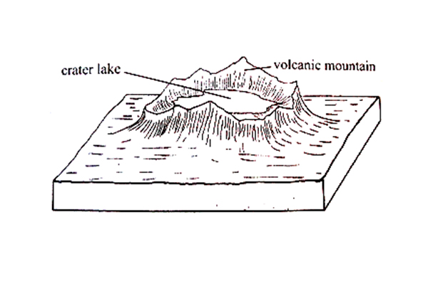
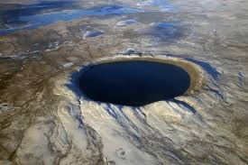
Rain water fills a crater to form a Crater Lake.
A crater is a basin-like feature formed on top of a volcanic mountain.
A big crater is known as a caldera.
Examples of crater lakes are L.Visoke on Virunga ranges, L. Chala, L. Simbi Nyaima and L. Paradise.
When lava fl ows and blocks the course of a river,the water collects behind the barrier of lava to form a lake. This kind of lake is called a lava-dammed lake.
Examples include; L. Kivu, L. Nyusi and L. Tana.
- Ice from the top of mountains erode the sides of mountains forming hollows called corries or cirques.
- When ice melts, water collects in these hollows to form lakes.
- Such lakes are called tarns, corrie lakes or cirque lakes.
- An example of such a lake is the Teleki Tarn, Gallery and hanging tarns on Mt. Kenya and Lake Speke and Catherine on Mt. Ruwenzori.
When a river fl ows through a lowland area, it forms meanders.
When a river fl ows through a bend, the water speed is faster on the outside of the bend than on the inside.
This causes erosion to take place on the outside of the bend and deposition on the inside.
Later, the strong force of water cuts off the meander.
Increased deposition then seals the cut-off meander to form an oxbow lake.
Examples of Ox-bow lakes are; L. Kanyaboli on R. Yala, L. Gambe on R. Tana and L. Otange on R. Rufi ji.
Lakes can be formed as a result of human activites in the following ways;
a) Quarrying and open cast mining creates hollows on the surface of the land. Rain water collects in the hollows to form lakes or large water ponds.
b) When dams are constructed across a river the water collects behind the dam to form a lake. Such lakes are mainly created to provide water for generating hydro-electric power or for irrigation.
Examples of man-made lakes in Africa are; L. Kainji on R. Niger, L. Kariba on R. Orange, L. Masinga on R. Tana, L. Cabora Bassa on R. Orange, L. Nasser on R. Nile and L. Volta on R. Volta.
Wind in the desert erodes soil until it makes depressions. Water oozes in these depressions to form lakes called oases. Quatarra depression has examples of oases lakes.

