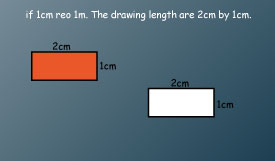
- To make a scale drawing we need to choose a linear scale.
- Using the linear scale we convert actual measurements of an object to drawing measurements that are used to make the scale drawing.
The image below shows a white board measuring 2m by 1m
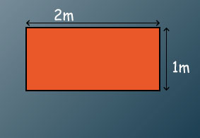
Determine the appropriate scale and make a scale drawing
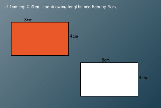
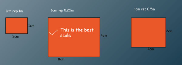
The most suitable scale is 1cm rep 0.25m since its easy to read and measure.
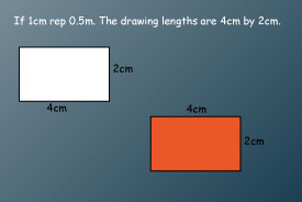
•Scale chosen should allow the scale drawing fit well on the available paper size.
Why are scale drawings important?
Careers that involve construction, architecture, city planning, design, and map-making all require knowledge of scale drawings.
Design of many different structures including machinery, furniture, cars, aeroplanes, computers and items like cups, plates,
Example
Use the map of Maine to estimate the distance between the towns of China and New Sweden.
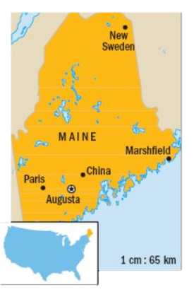
Solution
Since there are 4.5 centimeters between China and New Sweden, we can use a proportion to find the distance between the towns.

Write the proportion to find the distance (d) between towns.
1  d = 65 4.5 Cross multiply to solve.
d = 292.5
The actual distance between China and New Sweden is about 293 kilometers.
A scale model is very similar to a scale drawing. The scale model is a model of an object with dimensions that are in proportion to the actual object.
A scale model of the White House appears in Tobu World Square in Japan. Here is an image of the house as it appears in Japan.
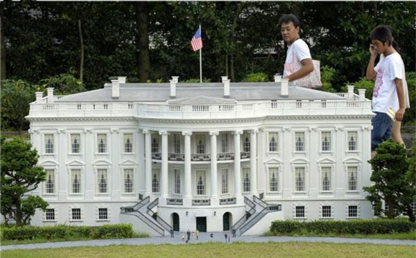
The scale is 1:25. The height of the main building of the White house is 8 feet. Find this height on the model.
1/25=h/25
Write the proportion to find the height (h) of the model.
1 85 = 25 h
cross multiply to solve 85/25 = 25h/25
Divide both sides by 25.
3.4 = h Solve.
Answer: The height of the main building of the model is 3.4 feet.
1. In a scale drawing of a rectangular plot, 7 cm represents the length of the plot which is 560 m. What is the actual width of the plot represented by 3.5 cm on the scale drawing?
A. 80 m B. 160 m C. 280 m D. 1120 m
2. On a map whose scale is 1:50000, a rectangular piece of land measures 3 cm by 2 cm. What is the size of this piece of land in hectares?
A. 15 B. 150 C. 1500 D. 15000
3. The scale drawing below represents shortest routes between towns M, N and P on a map. If the distance from M to P on the direct route is 240 km, what is the distance, in kilometres, from M to P through N?
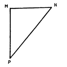
A. 720 B. 480 C. 300 D. 180
4. The scale drawing below shows the positions of flag post, school gate and the head teacher’s office. The scale for the plan is 1:10000.
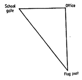
What is the actual distance, in metres, between the flag post and the school gate?
A. 7200 m B. 720 m C. 72 m D. 7.2 m
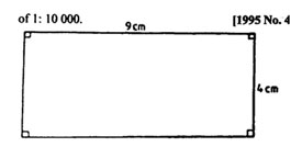
5. A rectangular field measuring 420 m by 600 m is to be represented on a scale drawing using the scale 1:20000. What is the area of the scale drawing in cm2.
A. 63 B. 6.3 C. 0.63 D. 0.063
6. On a map, a rectangular plot of land measures 6 cm by 4 cm. If the scale on the map is 1:1000, what is the actual area of the plot in square metres?
A. 24 m2
B. 2400 m2
C. 240000 m2
D. 24000000 m2
7. The diagram below shows a plot of land drawn to a scale of 1:10000.
What is the actual area of the plot in m2?
A. 36
B. 3600
C. 360000
D. 3600000
8. The scale of a building plan is 1:200. What length on the plan represents 5 m of the building?
A. 40 cm
B. 25 cm
C. 2.5 cm
D. 0.4 cm
1. A section of road measuring 2500 m in length is represented by a length of 5 cm on a Map. Which one of the following is the scale of the map?
A. 1:500
B. 1:5000
C. 1:50000
D. 1:500000
2. The distance between town P and town Q on a map is 5 cm. of the actual distance is 5 km, what is the scale in the map?
A. 1:100
B. 1:1000
C. 1:10000
D. 1:100000
3. The scale below represents three towns X, Y, and Z. The distance from town Y to town Z is 550 km.
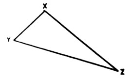
What is the distance from town Y to town Z through town X?
A. 1250 km
B. 770 km
C. 700 km
D. 480 km
4. The scale drawing below represents three towns K, L, and M.
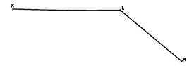
If the actual distance from K to M through L is 150 km, what is the scale used?
A. 1:1000000 B. 1:100000 C. 1:10000 D. 1:1000
5. A section of a road measuring 2 km is represented on a map by length of 10 cm. Which one of the following is the scale for the map?
A. 1:200
B. 1:2000
C. 1:20000
D. 1:200000

